
- New Equipment arrives!New GPS system arrives to expand the teams capability. After much deliberation and testing we … Continue reading
- Check Surveys & New combined
 Recent works have included check surveys for large industrial sites and the add-in of new … Continue reading
 - New Masonmap Products
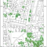 Tree data has just been added to the Masonmap OS portfolio. The option to buy … Continue reading
- New Equipment arrives!
Tag Archives: cad
New Repro Print System!
Our new print/copy/scan reprographics system has been installed in our Masonmap-Reprographics bureau. Using wax toner pearls, high speed printing and very long paper rolls we can achieve print runs like never before and output from CAD & Photo / posters … Continue reading