
- New Equipment arrives!New GPS system arrives to expand the teams capability. After much deliberation and testing we … Continue reading
- Check Surveys & New combined
 Recent works have included check surveys for large industrial sites and the add-in of new … Continue reading
 - New Masonmap Products
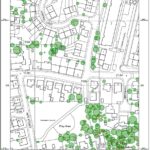 Tree data has just been added to the Masonmap OS portfolio. The option to buy … Continue reading
- New Equipment arrives!
Tag Archives: scotland
New Equipment arrives!
New GPS system arrives to expand the teams capability. After much deliberation and testing we have added additional Geomax GPS/GNSS rover system with tilt function.
Tagged central belt, coordinates, dundee, edinburgh, england, fife, geo, geomatics, geomax, glasgow, gnss, GPS, leica, london, mapping, mapping topo, professional, satellite, satellite dunfermline, scotland, survey, survye, topo, topographic, TS
Comments Off on New Equipment arrives!
Check Surveys & New combined
Recent works have included check surveys for large industrial sites and the add-in of new survey data to complete a project data set, for the next stage of its development. Working to site restrictions, coping with the changeable weather have … Continue reading
New Masonmap Products
Tree data has just been added to the Masonmap OS portfolio. The option to buy tree height information at the same time as a planning application product is here now and is very cost effective! A sample of the output … Continue reading
Tagged 1:1250, 1:2500, 1:500, dunfermline, england, fife, mapping, OS, pdf, planning application, printed mapping, scotland, tree data, UK, wales
Comments Off on New Masonmap Products