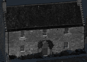
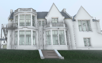
Laser Scanning

Fully three dimensional rapid, non-contact, accurate and objective method for the capture of the as-built environment, whether it be property, historic and ornate, infrastructure, plant and transportation assets and terrain, all are achieved quickly and digitally.

The ultimate capture method for complete record as it is today, ahead of real world change and may be repeated in line with change to record movement, instigate works and inspection records.

The capture of subjects in scale and its geospatial environment, enables Engineers, Architects and Designers to review, plan and construct with full understanding and knowledge of the in-situ environment that also provides as-built information pre build and information for historic reference, an ideal method for providing 3D data for building models.

3D laser scanning from the ground,  internally and combined with quality digital photography, provides an intimate insight into your area of interest, whether it be industrial, commercial, technology driven or for historical purposes, the greatest base information to work from or refer to.

Among the major benefits to clients is high accuracy of the scan data, the comprehensive coverage of the data, and the wide variety of environments and conditions in which the scanner can work. Laser scan data can also act as long term record of site conditions at the time of the survey, which can be returned to and modelled from as needed and as a surface monitoring tool for quantifying change over time.

Comments are closed.